
New Lawrence Loop Map Available
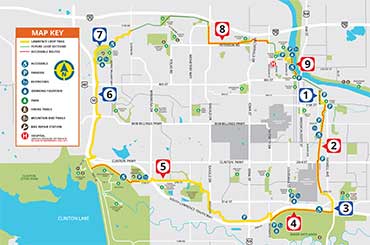
A new Lawrence Loop Map is available. Descriptions were developed to help trail users enjoy their experience on the Lawrence Loop by identifying sections of the Loop that will suit their interests and abilities. Trail lengths are approximate.
Red dots on the map identify the most accessible sections because of factors like easy access to parking and trail slopes.
To ensure your safety on the Lawrence Loop (or any trail) we recommend you use the trail with a friend, be aware of your surroundings, carry water, and exercise judgement when navigating the terrain.
Keep it safe, share the trail, and most of all, enjoy the Loop!